
National Aeronautics and Space Administration (NASA) and the Indian Space Research Organisation (ISRO) are cooperatively developing the NASA ISRO Synthetic Aperture Radar (NISAR). Expected to launch in 2024, this radar imaging satellite will monitor changes in the Earth’s surface associated with the movement of the crust and ice cover.
Mission Capabilities
NISAR has two Synthetic Aperture Radars (SARs) onboard, an L-band (L-SAR) and an S-band (S-SAR), and will be the first satellite to use two different radar frequencies. Both frequencies penetrate clouds and forest canopies, although the lower L-band frequencies can penetrate thicker vegetation so the Earth’s surface can be monitored independently of coverage. As such the L-SAR will be used to observe landscape topography and heavily forested areas. The higher S-band frequencies will be used to monitor soil moisture, particularly in polar regions as S-band frequencies are less perturbed by the ionosphere.
Performance Specifications
Both instruments will observe a swath of 242 km. L-SAR will handle frequencies of 1.25 GHz with a spatial resolution of 3 – 48 m, while S-SAR will handle frequencies of 3.2 GHz with a resolution of 3 – 24 m. The resolution of each SAR is dependent on the observation mode which varies by bandwidth and polarisation.
NISAR will follow a sun-synchronous orbit with an altitude of 747 km and an inclination of 98.4°. It will have a period of 100 minutes and repeat cycle of 12 days.
Space & Hardware Components
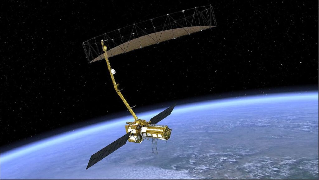
NISAR implements a modified ISRO I3K spacecraft bus, which is attached to the 9 m radar antenna boom which supports the 12 m wide radar antenna reflector. This will be the largest reflector antenna launched by NASA, and has been made possible by constructing it out of wire mesh which will fold out after launch.
NISAR will be able to provide frequent global coverage by using its SweepSAR design. SweepSAR works by transmitting radio waves to the entire swath, receiving echoes from parts of the swath in quick succession within a thousandth of a second, then processing them simultaneously and combining them. The transmission signal is sent out between the echoes being received.
NISAR (NASA-ISRO Synthetic Aperture Radar) Mission
NISAR is a joint NASA-ISRO (Indian Space Research Organization) Earth-observing mission with the goal to make global measurements of the causes and consequences of land surface changes. Potential areas of research include ecosystem disturbances, ice sheet collapse and natural hazards. The NISAR mission is optimized to measure subtle changes of the Earth’s surface associated with motions of the crust and ice surfaces. NISAR will improve our understanding of key impacts of climate change and advance our knowledge of natural hazards.
NISAR will be the first satellite mission to use two different radar frequencies (L-band and S-band) to measure changes in our planet’s surface less than a centimeter across. This allows the mission to observe a wide range of changes, from the flow rates of glaciers and ice sheets to the dynamics of earthquakes and volcanoes.
At the IAC (International Astronautical Congress) in Toronto, Canada ( Sept. 29-Oct. 3, 2014), NASA Administrator Charles Bolden and K. Radhakrishnan, chairman of ISRO, signed two documents to launch a NASA-ISRO satellite mission to observe Earth and establish a pathway for future joint missions to explore Mars. 1) 2) 3) 4) 5)
Under the terms of the new agreement, NASA will provide the mission’s L-band SAR (Synthetic Aperture Radar), a high-rate communication subsystem for science data, GPS receivers, a solid state recorder, and a payload data subsystem. ISRO will provide the spacecraft bus, an S-band SAR, and the launch vehicle and associated launch services. A launch of NISAR is targeted in 2021.
NASA had been studying concepts for a SAR mission in response to the National Academy of Science’s decadal survey of the agency’s Earth science program in 2007. The agency developed a partnership with ISRO that led to this joint mission. The partnership with India has been key to enabling many of the mission’s science objectives.
Spacecraft
The NISAR flight system design, development, integration, testing and operations are a joint venture, with equivalent-scale contributions from both JPL and ISRO. The suite of flight systems consists of the launch vehicle and free-flying observatory. The NISAR observatory is designed around the core payloads of Land S-band SAR (Synthetic Aperture Radar) instruments, designed to collect near-global radar data over land and ice to satisfy the Level 1 science goals. In addition to the two radar instruments, the NISAR payload includes a GPS (Global Positioning Ssystem) receiver for precision orbit determination and onboard timing references, a solid-state recorder, and a high-rate data downlink subsystem to enable transmission of the high-volume science data to the ground. 7) 8) 9) 10)
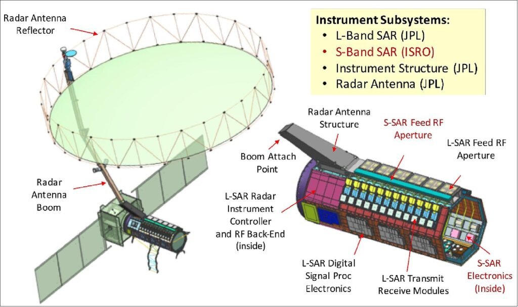
Figure 1 shows the fully integrated and deployed observatory system. The 12 m RAR (Radar Antenna Reflector) is at top, supported by the RAB (Radar Antenna Boom). The boom is attached to the RIS (Radar Instrument Structure), which is itself attached to the ISRO I3K Spacecraft Bus. Extending on either side of the bus are two solar arrays each with three panels that together supply approximately 4 kW of power when illuminated (i.e. at all times when not in eclipse or off Sun-pointing). The radar payload integration (L-band and S-band integration) will occur at JPL, and the overall observatory integration will occur at ISAC (ISRO Satellite Center) in Bangalore, India. The main elements of the system are illustrated in Figures 1 and 2.
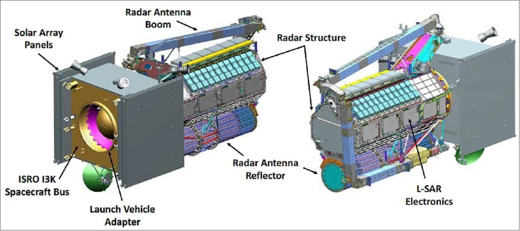
Spacecraft mass of ~ 2800 kg. Mission life = 3 years (5 years consumables). A modified I3K spacecraft bus of ISRO is used. The NASA project management is at JPL.
The NISAR spacecraft will accommodate two fully capable synthetic aperture radar instruments (24 cm wavelength L-SAR and 10 cm wavelength S-SAR), each designed as array-fed reflectors to work as SweepSAR scan-on-receive wide swath mapping systems. The mapping scenario calls for frequent sampling over broad areas to create a time series and allow for noise reduction through stacking methods. Thus, a high-rate instrument and data downlink systems are required. The average capacity of the envisioned data downlink is of the order of 26 Tbit/day, supporting the instruments which can produce at L-band from 72 Mbit/s in its lowest bandwidth mode to over 1500 Mbit/s in the most demanding high-bandwidth, multi-polarization mode. Table 2 summarizes the overall mission characteristics.
NASA contributions include the L-band SAR instrument, including the 12-m diameter deployable mesh reflector and 9-m deployable boom and the entire octagonal instrument structure. In addition, NASA is providing a high capacity solid-state recorder (with 9 Tbit capacity at end of life), GPS receiver, 3.5 Gbit/s Ka-band telecom system, and an engineering payload to coordinate command and data handling with the ISRO spacecraft control systems. ISRO is providing the spacecraft and launch vehicle, as well as the S-band SAR electronics to be mounted on the instrument structure. The coordination of technical interfaces among subsystems is a major focus area in the partnership.
| Element | Description |
| Expected launch date | Late 2021 |
| Orbit | 12-day exact repeat, sun-synchronous, dawn-dusk, polar, 747 km altitude |
| Mission duration | 3 years nominal, with extended mission fuel reserve |
| Science data downlink approach | • 30-45 minutes of data downlink per orbit at 3.5 Gbit/s data rate through polar ground stations • 1 Gbit/s direct downlink to India over Indian ground stations |
| Observation approach | • L-band multi-mode global radar imaging • S-band multi-mode targeted radar imaging • Dual-frequency capable • ~240 km swath for all modes • Full pol, multiple bandwidths up to 80 MHz • Near-zero Doppler pointing, fixed boresight • Primarily right looking, with occasional flip to the opposite side for better polar coverage. The project is considering an alternative that is purely left-looking for the entire mission, relying on the international SAR constellation to fill in coverage around Arctic pole |
| Mapping approach | Under study – current approach defines a reference mission with fixed modes over broad target areas. |
Mission Status
• February 23, 2024: Jennifer Larson, Consul General, U.S. Consulate General, Hyderabad, said that the U.S. and India are aiming to launch the joint NISAR satellite from Andhra Pradesh in a few weeks. There will be Tiger Triumph exercise off the A.P. coast in less than a month, she added. 29)
• March 24, 2021: An SUV-size Earth satellite that will be equipped with the largest reflector antenna ever launched by NASA is taking shape in the clean room at the agency’s Jet Propulsion Laboratory in Southern California. Called NISAR, the joint mission between NASA and the Indian Space Research Organization (ISRO) has big goals: By tracking subtle changes in Earth’s surface, it will spot warning signs of imminent volcanic eruptions, help to monitor groundwater supplies, track the melt rate of ice sheets tied to sea level rise, and observe shifts in the distribution of vegetation around the world. Monitoring these kinds of changes in the planet’s surface over nearly the entire globe hasn’t been done before with the high resolution in space and time that NISAR will deliver. 12)
– The spacecraft will use two kinds of synthetic aperture radar (SAR) to measure changes in Earth’s surface, hence the name NISAR, which is short for NASA-ISRO SAR. The satellite will use a wire mesh radar reflector antenna nearly 40 feet (12 meters) in diameter at the end of a 30-foot-long (9-meter-long) boom to send and receive radar signals to and from Earth’s surface. The concept is similar to how weather radars bounce signals off of raindrops to track storms.
Figure 4: This animation shows how the NISAR spacecraft will deploy its radar reflector antenna after launch. Nearly 40 feet (12 meters) in diameter, the reflector will sit at the end of a 30-foot-long (9-meter-long) boom, sending and receiving radar signals to and from Earth’s surface (video credit: NASA/JPL-Caltech)
– NISAR will detect movements of the planet’s surface as small as 0.4 inches (1 cm) over areas about the size of half a tennis court. Launching no earlier than 2022, the satellite will scan the entire globe every 12 days over the course of its three-year primary mission, imaging the Earth’s land, ice sheets, and sea ice on every orbit.
– Activities such as drawing drinking water from an underground aquifer can leave signs on the surface: Take out too much water, and the ground begins to sink. The movement of magma under the surface before a volcanic eruption can cause the ground to move as well. NISAR will provide high-resolution time-lapse radar imagery of such shifts.
Launch
A launch of NISAR is planned in 2024 on an ISRO GSLV (Geosynchronous Satellite Launch Vehicle) Mark II launch vehicle of ISRO from SDSC (Satish Dhawan Space Center) in Sriharikota, Andhra Pradesh, India. 21)
Orbit: Sun-synchronous dawn-dusk orbit, altitude of 747 km, inclination = 98.4º, LTAN at 18 hours, repeat cycle of 12 days.

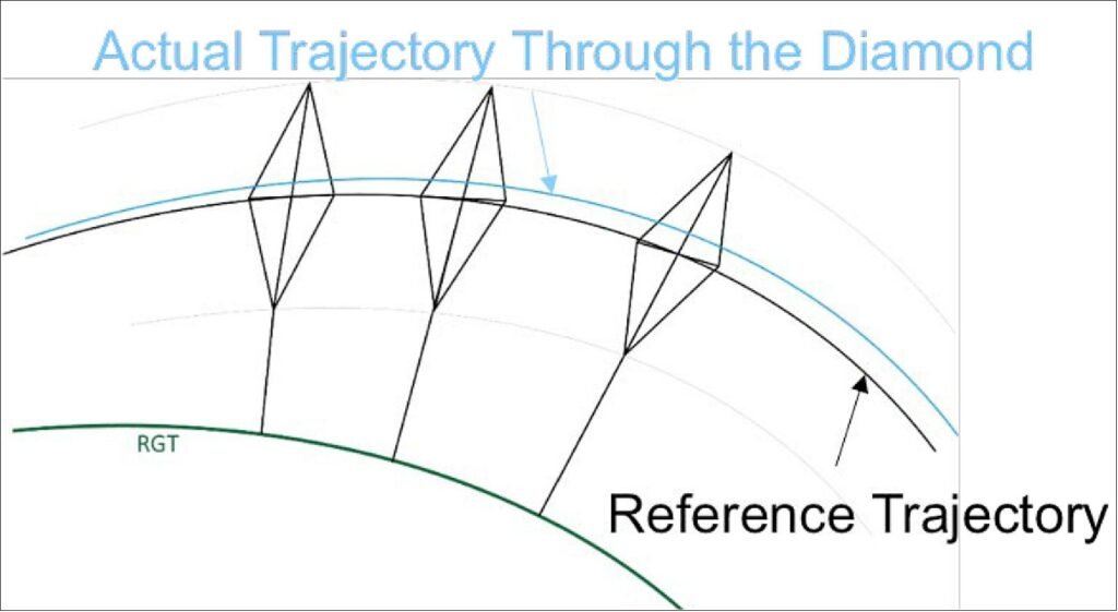
During science operations, NISAR will fly within a diamond-shaped orbital corridor defined for each of the repeat cycle’s 173 orbits and tied to the rotating Earth (Figure 4-3). This corridor is defined to enable accurate correlation of science observations from pass-to-pass and cycle-to-cycle, supporting assessment of changes in the science targets. The dimensions of the diamond were calculated as an upper bound on acceptable error produced by a non-zero baseline between passes/cycles between three primary factors of phase unwrapping error, geometric decorrelation and topographic leakage, but ultimately dominated by the former (phase unwrapping error, i.e., high fringe rate in regions of large topographic relief).
The center of the Diamond is defined by the 173-orbit reference trajectory (referred to as the Reference Science Orbit), which is fixed to the Earth’s surface and is exactly repeated every 12 days. The Diamond can be thought of as a fixed altitude, longitude and latitude profile that spans the entire repeat cycle; a conceptual representation of this corridor is shown in Figure 6. To maintain the Diamond, the JPL Navigation team plans on executing maneuvers over the long ocean passes (Atlantic and Pacific) as much as possible not to impact science data collection (Ref. 7).
Commissioning Phase: The first 90 days after launch will be dedicated to Commissioning, or IOC (In-Orbit Checkout), the objective of which is to prepare the observatory for science operations. Commissioning is divided into sub-phases of Initial Checkout (ISRO engineering systems + JPL Engineering Payload checkout), Deployments, Spacecraft Checkout and Instrument Checkout. Philosophically, the sub-phases are designed as a step-by-step buildup in capability to full observatory operations, beginning with the physical deployment of all deployable parts (notably the boom and radar antenna, but not including the solar arrays which are deployed during Launch Phase), checking out the engineering systems, turning on the radars and testing them independently and then conducting joint tests with both radars operating.